
Text by James Bow.
See also:
- Davisville Yard
- Changes to the Original Yonge Subway Line
- Station Pages: Union | Dundas | College | Bloor-Yonge | Davisville | Eglinton
- Station Walkthrough Videos: Queen | Rosedale | Summerhill
- The North Yonge Extensions.
Public Transit on Yonge Street
- 1796 - Yonge Street opens between Lake Ontario and Lake Simcoe
- 1800 - 1880s - Stagecoach operations along Yonge Street
- 1849 - Burt Williams' horse-drawn omnibus service begins between St. Lawrence Hall and Yorkville Town Hall.
- 1861 - Yonge streetcar service within Toronto city limits (and Town of Yorkville) begins
- 1862 - Burt Williams' sells/shuts down omnibus service
- 1885 - The Metropolitan Railway (later Toronto & York) begins service on Yonge north of Toronto's City Limits, eventually reaching Lake Simcoe
- 1930 - North Yonge Railways replaces Lake Simcoe line, operates between Toronto's city limits and Richmond Hill
- 1948 - North Yonge Railways "temporarily" switches to bus operation due to power shortages.
- 1949 - North Yonge's "temporary" switch to buses becomes permanent.
- 1954 - Yonge Subway Opens between Eglinton and Union
- 1954 - DOWNTOWN bus, YONGE NIGHT bus and YONGE trolley bus start operations
- 1973 - Yonge subway extends to York Mills
- 1974 - Yonge subway extends to Finch
- 1977 - GO Transit takes over 59 NORTH YONGE bus
- 1989 - 27 DOWNTOWN and 97 YONGE merged into single route.
- 2003 - York Region Transit takes over GO Transit's Yonge 'C' Bus operations
- 2005 - York Region Transit establishes VIVA Bus Rapid Transit Service Between Finch Station and Newmarket
- 2012 - Bus rapid transit construction begins on Yonge in York Region
- 2020 - Rapidways for VIVA Blue service on Yonge open from Highway 7 to Major Mackenzie and Crosby to 19th Street in Richmond Hill, and from Savage-Sawmill to Davis Drive in Newmarket.
- 2031 - Possible opening of Yonge subway extension to Langstaff?
Getting Started (See also Early History)
Since the Town of York was founded in 1793, the east-west “Main Street” of what became the City of Toronto has shifted north as the city has grown out from its original boundaries. The main north-south thoroughfare, however, quickly became Yonge Street and has remained Yonge Street ever since. This former dirt highway running from Lake Ontario to Holland Marsh, named after a friend of Governor Simcoe, eventually connected a string of towns and villages to the provincial capital. Pressed against Lake Ontario to the south, the City of Toronto has grown north along this axis since its founding.
It is no surprise that, when the City of Toronto started to come of age, the first subway proposals suggested running trains beneath or near this main thoroughfare. A number of proposals emerged between 1909 and 1912, but the public rejected subways in a plebiscite in 1912, forcing the issue into dormancy for another thirty years.
Toronto continued to grow through the 20s and the 30s, and so did society’s love affair with the automobile. Then the Second World War arrived. Although the onset of hostilities put car buying on hold and brought passengers back to the streetcars, the flow of commuters from home to work strained Toronto’s road and transit network. The end of hostilities and the repatriated soldiers would mean that development, suppressed after fifteen years of depression and war, would suddenly revive and explode. This prospect convinced many, the TTC among them, that bold action had to be taken to prevent the city from choking on its own traffic.
The TTC formed a Rapid Transit Department and worked on a proposal between 1942 and 1946. Finally, the TTC proposed a “rapid transit subway” beneath Yonge Street running from Eglinton Avenue south to Front Street and then west along Front to Union Station. A Queen streetcar subway would operate to the north of Queen Street from Trinity Park to McCaul, beneath Queen Street from McCaul to Mutual, and then north of Queen Street in an open cut from Mutual to St. Paul. The matter was put to voters on a January 1, 1946, plebiscite and overwhelmingly approved. Toronto City Council approved construction four months later.
Construction Begins (See Also: How Cut and Cover Works)
The 1946 referendum approved construction on the condition that the federal government could subsidize the project by 20%. The proposed federal funding never materialized. Although the federal Minister of Reconstruction, C.D. Howe, sent a letter on October 3, 1945, promising the TTC financial assistance, the deal fell through when the federal Government and the Province of Ontario failed to agree on a postwar employment program that would support the project. The city proceeded with the subway anyway, scaling down the proposal. The Queen streetcar subway was temporarily forgotten, and what had begun as a two-subway project costing $42.3 million was reduced to a single line costing an estimated $28.9 million plus $3.5 million for rolling stock.

|
|
Curt Frey donated this photograph (possibly by P. Lambert) of the subway construction north of Ellis Portal and Davenport Road. Rosedale station is under construction in the distance. |
Construction began on September 8, 1949 (two years late due to post-war shortages) with the City of Toronto launching work with a ceremony emceed by Monty Hall. Ontario’s Lieutenant-Governor Ray Lawson climbed inside a pile driver and pulled the first lever to pound the first “soldier” beam into place. All the local radio stations carried the entire event live. The official party then moved to the Royal York Hotel while the real workers got down to work.
“Cut-and-cover” technique was chosen as the means to build the underground portions of the 7.4 kilometre (4.6 mile) line. This was chosen because it was far less expensive than using a tunnel bore. A large trench was dug into Yonge Street, utilities relocated, and steel cross members welded into place. These steel cross members were then used to support heavy timbers that provided a deck that allowed traffic to return to the street while work proceeded beneath. A total of 1.7 million cubic yards (1.3 million cubic metres) of material were removed and some 14,000 tons (12,700 metric tons) of reinforcing steel and 1.4 million bags of cement were put into place. The material removed was trucked to Ashbridges Bay and was used to create acres of new land out of Lake Ontario.
As construction headed north from Front Street, crews ran into solid rock, three to eight feet in depth, stretching as far north as Queen Street. This required dynamite charges to remove, and blasts occurred twice daily, at noon and 4:30 pm. Most of the subway construction proceeded without incident. The only serious accident to occur was not fatal, but resulted in the area south of Adelaide Street being seriously flooded, to a depth of 20 feet in places. Following a heavy rain on July 24, 1950, a temporary storm sewer gave way and caused the mess.
The use of temporary decking reduced the inevitable traffic disruption caused by cut-and-cover construction. Traffic was interrupted only during the initial excavation before the cut was deep enough to deck over, and then when the decking was finally removed to allow the street to be rebuilt. But streetcar diversions were still necessary. The TTC went so far as to lay down temporary streetcar tracks on such side streets as Alexander, as opposed to longer diversions along the streets which already had tracks in place. Although the track was temporary in nature, and probably built using spare or surplus materials, the TTC still took the time to set these temporary tracks into the streets, instead of laying them on the surface. A number of railfans snapped shots of Witt trains operating on these single tracks through residential neighbourhoods.

|
|
Artist conceptions of College (above) and Wellesley (below) stations. Wellesley station has changed considerably since it opened in 1954, with a building built above the original bus terminal. |

|
The Yonge line was initially to be cut and cover from Front Street up to north of College (Alexander Street), after which the line would jog approximately 150 feet east of Yonge Street and proceed north in an “open cut”. The line would be open to the air, although below the general height of land, passing beneath a number of bridges carrying the cross streets. However, this would have required a large number of houses and buildings to be demolished, and it was feared that the resulting trench might have reduced the nearby property values. As a result, it was decided that cut and cover would be continued as far north as Davenport.
The cut-and-cover technique still required the demolition of many homes, although it left developable land behind once tunnel construction was complete. When the subway passed beneath buildings that weren’t to be demolished (including areas around Bloor Street, St. Clair and possibly Summerhill stations), great care was taken to support the buildings while work continued beneath. Concrete underpinning was placed under foundations and cellar floors temporarily removed as the excavation continued down for several feet. Concrete “caissons” were then poured to support one end of a steel girder that would support the buildings above, and prevent the roof of the subway tunnel caving in below. Once the subway structure was built, all excavation was backfilled and the buildings got their cellar floors back.
North of Church Street and Davenport Road, the line emerged from tunnel. This is the only tunnel portal on the TTC to bear a sign naming it: Ellis Portal, named after a street in the area that disappeared as a result of the subway construction. From Ellis Portal, the line proceeded north in an open cut to the Canadian Pacific tracks near the former North Toronto station. Here, the line dove underground again to Shaftesbury Avenue, two blocks north. This section was tunnelled beneath the tracks (without the telltale round bore, suggesting that this short section was mined), as the railway would not have appreciated cut-and-cover construction. Emerging in an open cut again, the line continued north to Woodlawn Avenue, then dove underground for St. Clair station and to cross Yonge Street, emerging just north of Lawton. A large tract of land near the Belt Line railway was cleared to make way for Davisville yard. Alexander Muir Memorial Garden, which occupied the site, was moved north to its present location on Yonge Street and St. Edmund’s Drive in Lawrence Park. The relocation cost $100,000 and the relocated park reopened on May 28, 1952.
Proceeding north through open cut, the line dove underground again at Berwick. The complex at Eglinton station was built on the site of TTC’s Eglinton carhouse. As construction continued, the carhouse was converted into a bus and trolley bus operation, in anticipation of the removal of streetcars from the Yonge streetcar line.
Initially, it was expected that the Yonge subway would be finished in 1953, but the Korean War intervened. The resulting steel shortage dragged the work on until 1954. The final cost of the Yonge subway was tallied at $67 million.

|
|
A Gloucester train led by car number 5029 heads southbound from Rosedale station towards Ellis Portal. Photo donated by Curt Frey. |
Toronto’s First Subway Cars
With the construction of the subway well underway, the TTC set about searching for equipment to operate on it. They turned, first of all, to New York and Chicago, two large cities with well-established or developing subway networks. In particular, they seriously considered Chicago’s 6000 series PCC rapid transit cars, built by St. Louis Car Company using components salvaged from 4000 series Chicago PCC streetcars. Early drawings of the Yonge subway show trains comprised of cars about as long as PCCs, and in roughly the same colour scheme.

|
|
A Gloucester train heads northbound along the open cut between Davisville and Eglinton stations. Photo donated by Curt Frey. |
As it had found when it tried to purchase new PCCs in the early 1950s, the price tag for PCC-style subway cars was too high for the TTC’s liking, both from Canadian and United States car builders, and the Commission went further afield. They finally settled upon the Gloucester Railway Carriage and Wagon Company in Gloucester, England, purchasing technology similar to what was being run on the London Underground. The history of these cars are covered in more detail in their own web page.

|
|
North of the Davisville yard lead, two Gloucesters pass each other. This shot is taken from the Manor Road footbridge between Yonge Street and Duplex Avenue with the Hillsdale Avenue bridge in the background. Photo donated by Curt Frey. |
The first order for Toronto’s first subway cars was placed in November 1951, for a total of 104 units. The original contract price was $7,800,000, including spare parts. The first cars arrived in the Port of Montreal in 1953, loaded on flat cars and taken by rail to Hillcrest shops. Further deliveries of Gloucester cars were made directly to Davisville yard via the CN siding that was all that remained of the Belt Line Railway. Cars 5004 and 5005 were the first to travel under their own power, on September 20, 1953. Further trips were made in October of that year to check tunnel clearance.
Canada’s First Subway Opens
After five years of construction and preparation, the Yonge subway was ready open. Ceremonies were planned for the morning of March 30, 1954. Ontario Premier Leslie Frost, Toronto Mayor Allan Lamport, Metro Chairman Frederick Gardiner and TTC Chairman W.C. McBrien officially opened the line. Crowds of people, including politicians from all three levels of government, TTC employees and print, radio and newsreel journalists, and early television video cameras (from CBLT, which had come on air on September 8, 1952), gathered at Davisville station around 11:00 a.m. to listen to several self-congratulatory speeches. TTC Chairman McBrien’s speech called for the immediate commencement of construction on the Queen Street streetcar subway and several other sweeping measures to reduce downtown congestion, including fringe parking lots, one-way streets and the adoption of staggered working hours. In his words, the Yonge Street subway line was “not the final solution of Toronto’s traffic problems. It is only the start of combating this monster. Many other (rapid transit) lines will have to be built in the future.” The chairman went on to warn that the TTC could not afford to build more subway lines without government assistance, a statement that would be verified in just five years.
Finally, Premier Frost and Mayor Lamport pushed a lever forward, changing a nearby block signal from amber to green. The subway was officially open.
Over six hundred invited guests boarded a train that departed Davisville station for Eglinton at 11:50 am. At 11:56, the train departed Eglinton for Union, arriving at exactly 12:10 pm. “Eglinton to Union in 12 Minutes” the newspaper headlines cried, although the first trip actually took fourteen minutes. Previously, that trip on the Yonge streetcar took 30 minutes, assuming traffic was favourable. A second train carried the overflow of dignitaries directly from Davisville to Union Station, and the party again moved to the Royal York Hotel. At 1:30 pm. the Yonge subway opened for the public. Those who had taken the streetcar to work took the subway home.
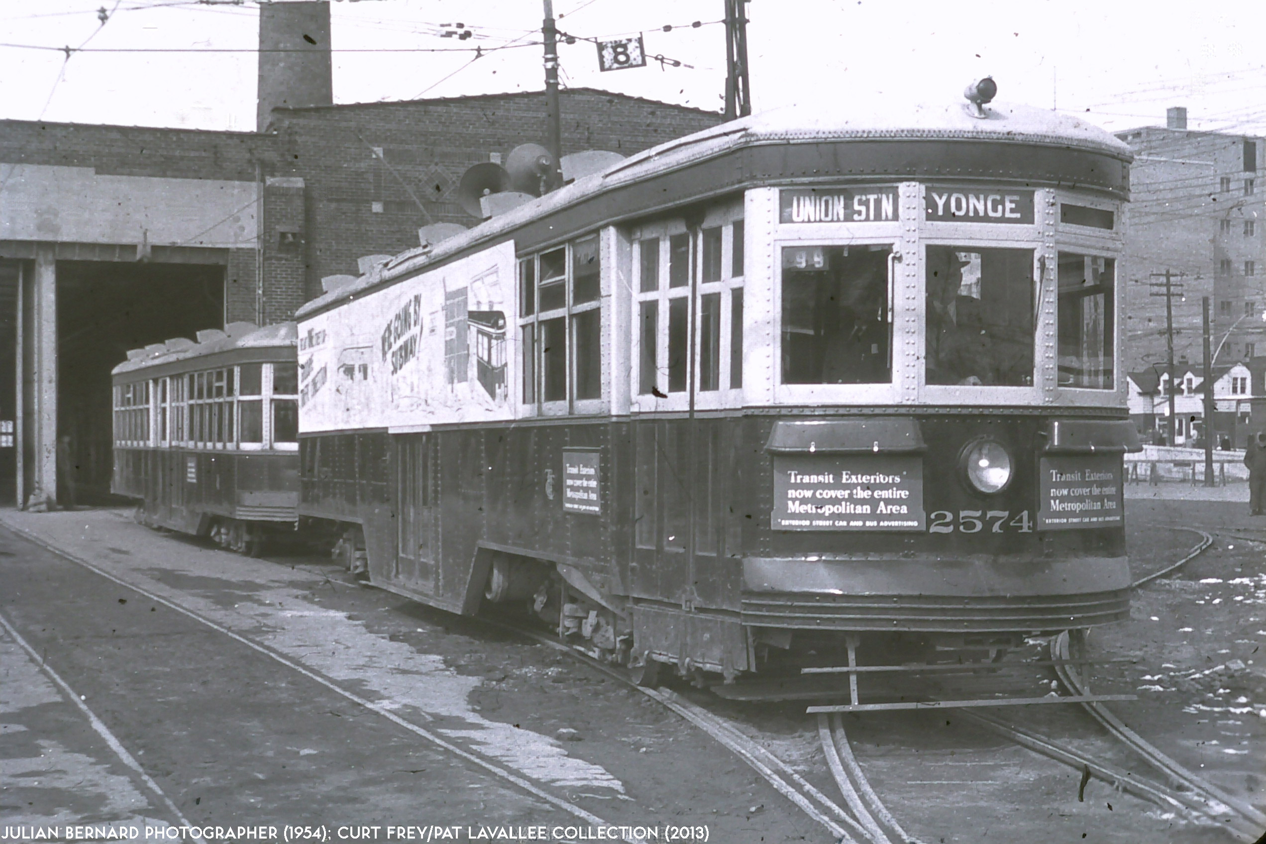
|
|
(Above) The end of an era. Witt #2574 and trailer 2897 prepare to depart Eglinton carhouse for Union Station for the last run, ever, of the Yonge streetcar. Photo donated by Curt Frey. |
The Yonge streetcar line, established in 1861, faded from existence between 1:30 p.m. and 2:00 p.m. that afternoon. Earlier that month, the line had been cut back from Toronto’s northern city limits to Eglinton Avenue, looping counterclockwise around the traffic office at Eglinton carhouse. Soon thereafter, TTC crews worked on installing trolley bus overhead for a new route to run from Eglinton station to the city limits. Now, the last streetcars dropped off their passengers at Union Station and filed into Harbour Yard at the base of York Street. The last northbound streetcar left Front and York for Eglinton at 1:54 p.m., and the very last train, a special comprised of Witt 2574 and trailer 2897, departed Eglinton for Front Street at 2:30 p.m. Signs proclaiming it to be the last train were so large that most of the invited party of members from the Upper Canada Railroad Society rode in the trailer, so they could be able to see out.
For many of the cars, it would be the last time they would operate. The Yonge subway meant the end of service not only for Toronto’s premier streetcar line, but also for the Bay streetcar, as the St. Clair services were realigned into the subway.
Starting at 1:30 p.m. Dupont streetcars were extended south on Bay Street to the Ferry Docks. The last Bay car was scheduled to leave Lansdowne Loop for the Ferry Docks at 1:29 p.m., and the Ferry Docks for “Wychwood” (St. Clair Carhouse) at 2:07 p.m. Earlscourt cars operating from St. Clair and Lansdowne to the Yonge subway replaced Bay cars on St. Clair Avenue while Avenue Road lost streetcar service altogether. Rogers Road streetcars were also extended east along St. Clair to the subway during rush hours. This change also resulted in the abandonment of the Bathurst tripper service along Front Street. Bathurst cars now ran exclusively from St. Clair Avenue to Adelaide and east on Adelaide to loop via Victoria, Richmond and Church. Other tripper services which fell included the Church Tripper and the downtown version of the Danforth tripper. These were replaced by extra streetcars operating on the Bloor route, and a revised Danforth tripper that ran from Luttrell to Bedford Loop, making connections with the Yonge subway at Bloor station. The Carlton tripper also ceased operation.
The CHURCH streetcar operated for almost two months after the opening, but was bussed on May 16, 1954 to reduce the TTC’s electrical demands. The higher than expected electrical demand from the Yonge subway was blamed for a number of “brown-outs” in the area. Tracks were soon taken up or covered over on Front Street from York to Sherbourne.
A large number of Witts were rendered surplus as a result of these changes. The TTC retired every Witt trailer and all remaining two-man Peter Witt cars. Many were taken from Harbour Yard directly to the scrap heap.
A lot of time had to be spent fixing Yonge Street in the aftermath of the subway opening and the streetcar abandonment. The rehabilitation of Toronto’s main thoroughfare continued throughout 1954, with tracks either being removed or paved over. A Yonge Street reopening ceremony was scheduled for October 20, 1954, but then Hurricane Hazel intervened. Although technically only a tropical depression by the time it hit Toronto, this disaster still caused over $24 million in property damage and killed more than eighty Torontonians. The reopening ceremony was quickly reorganized into a fund-raising event to assist the storm victims.
The Yonge subway, however, was an overnight success. Riders flocked to try out the line, and commuters continued to use it long after the novelty wore off. Two-car Gloucester trains that were supposed to operate during periods of low ridership became very uncommon. Four-car trains became the minimum, and six-car trains standard in service. Eventually, ridership increased to the point where eight-car Gloucester trains operated from Monday through Saturday from the early morning to the early evening. Likewise, when the longer Montreal Locomotive Works and Hawker Siddeley cars arrived on the subway, Sunday service occasionally saw two-car Hawker trains at first, although four-car trains became the minimum and, after the 1990s, six-car trains became standard during all hours of operation.
The Design of the Yonge Subway.
The initial design of the Yonge subway stations was functional, with the walls covered in Vitrolite tiles in a simple design using a different pair of colours for each station. All stations except the two terminals had separate northbound and southbound platforms with the tracks in between; the eight stations of this design that were underground (King, Queen, Dundas, College, Wellesley, Bloor, Summerhill and St. Clair) were each divided lengthwise by a single line of painted, but otherwise bare, steel girders between the tracks, supporting the roof. Advertising panels were mounted on these girders. When the Vitrolite tiles were later replaced, the ad panels were moved to the platform walls, reducing the cost and also allowing them to be seen from the trains. The two open-air stations, Rosedale and Davisville, had no overall roofs and therefore no supports between the tracks.
The terminal stations, Eglinton and Union, each had a centre platform between the tracks, with two lines of roof supports along it (except where walls served this purpose, such as at the stairwells). These pillars contained steel girders but were finished in the same style as the walls.
Scissors crossovers were installed at the entrance to Union station, just north of King station, just south of College station, just north of Bloor station, just south of St. Clair station and at the entrance of Eglinton station. Because of the sharp curve between King station (under Yonge Street) and Union station (under Front), the two crossover tracks at Union had to be at a gentler angle than normal. Because of this angle, normal frogs would not work at the centre of the diamond, where the corresponding rails of the two tracks cross. Instead, a switch diamond was installed. This avoided the problem by using two pairs of switchpoints, which could be set for one track or the other. It is almost like two ordinary switches placed point-to-point, except that the tracks are aligned to allow only two through routes.
Davisville station was given a three-track design, which is still unique on the system, due to its location adjacent to the Davisville Yard. Approaching the station from either direction, a single crossover leads from the northbound to the southbound track, and then the southbound track splits into two tracks, with the southbound platform between them. The turnouts to the yard are off the west track, which can therefore be conveniently used for trains entering or leaving service, as well as an emergency diversion in case a train fails at this station on either of the other two tracks.

|
|
Artist conceptions of King (above) and Queen (below) stations. Simple to start with, with lots of stuff added later |

|
By today’s standards, the fare booth area and street entrances of most stations were cramped. At Union station, entrances from each side of Front Street led to a single fare-collection area at mezzanine level. King was similar, but its southbound platform added an unstaffed secondary exit in 1955, with one-way flow enforced by an escalator rather than a turnstile; this exit, leading directly to the corner of Melinda Street, is still in use today.

|
|
Queen station today (Main entrance, northbound side), having seen many renovations and even a retiling in the intervening years. Photos by David Cavlovic. For comparison, see this shot at the very bottom, showing the northbound Queen platform circa 1975. |
 
|
The main entrance to Queen station, directly under the intersection of Yonge and Queen, had separate platform-level fare barriers on the northbound and southbound sides, but the two sides were connected within the fare-paid area by a pair of under-track passages. These were located on either side of the roughed-in station area for the Queen streetcar-subway line, and would have become the connecting passages between the two lines had the latter been built. Queen station also had a second staffed entrance serving Albert and Shuter Streets, with fare collection at mezzanine level. There was also initially a no-turnstile escalator exit from the southbound platform; this led directly into the basement level of the old Eaton’s store, and was closed when the new store in the Eaton Centre replaced it. Underground passages also connected the main entrance not only to Eaton’s but also to the Simpson’s (now The Bay) and Woolworth’s stores, setting a pattern followed by many later stations.
Dundas station was probably placed at a very shallow depth due to the expensive rock blasting mentioned previously; it was, and still remains, the only station with separate fare-paid zones for each platform. The turnstiles were along the edge of the platforms, with stairs leading directly to the street. College station had a single mezzanine fare-collection area, similar to Union and King.
At Wellesley, unlike the five stations above, the subway was offset from the street. This allowed a small bus terminal to be built over the tracks, giving a convenient layout where passengers could change between bus and subway within the fare-paid zone rather than using a paper transfer. The fare barrier was at street level within the bus terminal building, so no mezzanine level was required.
The most noteworthy feature of Bloor station was its pair of special “transferway” streetcar platforms in the middle of Bloor Street, where it passed over the subway just east of Yonge. Similar in some respects to the streetcar safety islands that exist today on many streetcar routes, the Yonge subway transferway was wider, sheltered, and had stairs leading directly to the subway platforms. Cars were not allowed into the transferway. The platforms were long enough to house two PCC MU trains, and during rush hours separate sections of each platform were used to load and unload passengers. In contrast to this direct connection, passengers not transferring from streetcars had to take a passage leading south from Bloor Street to reach the small mezzanine level with the station’s fare barrier. The Bloor transferway continued to be used until 1966, when the first phase of the Bloor-Danforth subway opened; the south curb line of Bloor Street still shows the deviation where the street was widened for traffic to pass by it.
Rosedale station, like Wellesley, had its fare barrier at street-level just inside the entrance; the subway platforms here were in an open cut, so the entrance and the bus terminal were offset to one side, with stairs leading down to the platforms. Summerhill’s entrance layout was similar to Wellesley’s, but without the bus terminal since no bus routes served the station. At St. Clair, the main entrance featured a street-level fare barrier, but this was connected via a mezzanine level both to the subway platforms and the surface-route terminal; a second staffed entrance at the other end of the mezzanine connected to Pleasant Boulevard. Davisville had a similar layout to Rosedale.
Of all the stations, only Eglinton, where numerous connections with suburban buses were made, offered extensive facilities to handle large crowds. A large mezzanine level within the fare-paid area connected the stairs and escalator from the subway platform with stairs to two street entrances and to nine street-level bus platforms; an additional bus platform with multiple stops was outside the paid area. Eglinton station also boasted a set of washrooms, the only ones on the subway until the Bloor line opened in 1966.


|
|
(above) Two artists renderings show the original Bloor station, its relationship to Bloor Street, and the Bloor streetcar transferway. Note the curve in the southern sidewalk to accommodate the platform in the middle of the street. (below) This photograph, by Julian Bernard, donated by Curt Frey, shows the transferway in action. |

|
Initially, paper transfers were required to change between subway and surface vehicles and all stations from College to Union. All other stations (except Summerhill) featured bus, trolley bus, or streetcar platforms within the subway’s fare-paid zone, allowing riders to transfer without any fare check. Particularly noteworthy was Bloor station, whose streetcar platforms were located in a special “transferway” in the middle of Bloor Street, just east of Yonge. Similar in some respects to the streetcar safety islands that exist today on many streetcar routes, the Yonge subway transferway was wider, sheltered and had stairs leading directly to the subway platforms. The transferway was long enough to house two PCC multiple-unit trains and, during rush hours, separate sections of each platform were used to load and unload passengers. The platform continued to be used until 1966, when the first phase of the Bloor subway opened. Evidence of this transferway can still be seen today in the curve in the south side of the street, just east of Yonge Street. The sidewalk narrowed to make room for the platforms and for the lanes of traffic. Cars were not allowed into the transferway.
Changes Since the Opening
As the oldest segment of Toronto’s subway network, the original Yonge subway has seen the most change. As Toronto’s downtown grew and redeveloped, use of the line increased. Many mezzanines were expanded, escalators were added, and some stations got additional, completely new entrances (King, Bloor, St. Clair, Davisville and Eglinton). Eglinton station has had multiple changes to its entrances and mezzanine configuration, most recently including a complete replacement of its bus terminal. As Union Station became the hub of a large and growing commuter train network known as GO Transit, the mezzanine level at the TTC’s Union station was expanded and reconfigured to handle the additional loads, and even to allow people not taking the TTC to cross through it to the Royal Bank Centre. A skyscraper boom in the sixties created a sprawling complex of shopping concourses beneath the downtown streets known unofficially as the “Underground City” (officially known as PATH since 1990). Built to connect office workers to the subway, PATH has also been responsible for many of the changes seen at Union, King and Queen stations. The construction of the Toronto Eaton Centre at Dundas and Yonge significantly altered that station, with several entrances built into the mall, and an enclosed connection between the platforms (albeit outside the fare-paid zone) finally built.
Redevelopment altered Wellesley and Davisville stations, with office buildings being built over what had previously been open-air bus terminals. In 1958, the TTC opened its new headquarters over top of the Davisville station bus terminal, and a shopping and office complex over top of Eglinton station continues to net the TTC hundreds of thousands of dollars in rent payments each year.

|
|
A train heads northbound towards St. Clair station. Woodlawn Avenue is above the tunnel portal. This open cut was decked over for development in the early 1970s. Photo by R. Hill; donated by Rob Hutch. |
The cut and cover section between Summerhill and St. Clair stations were decked over in sections in the late 1960s and the early 1970s (click here for more information). The new tunnel retains the sloped sides of the original open cut. The original four road overbridges, unevenly spaced, can still be seen inside the newer tunnel between Summerhill and St. Clair stations. These road bridges are located at Summerhill, Woodlawn, Jackes, and Rosehill Avenues. These road bridges, like the rest on the original Yonge line, used to be identified by a black on white sign, and many are still viewable, though in various stages of decay. Several other overbridges between Bloor and Eglinton stations still have clearly visible and legible street signs, but some have completely rusted to illegibility (including Price) while others are missing or in one case half-fallen (Hillsdale, seen from northbound train as of January 2001).
Little-used scissors crossovers at King, College (officially known as Gerrard crossover) and St. Clair (officially known as Rosehill crossover) disappeared in May 1984, June 1985 and March 1986 respectively during track rehabilitation. This change was made to reduce maintenance costs. The King and College sites were easy to spot by the gaps in the centre tunnel wall. St. Clair’s crossing was located immediately south of the Pleasant Boulevard portal, and thus had no centre wall in which to leave a gap behind. In 2012, the TTC decided to put these crossovers back, ahead of plans to install automatic train control over the whole of the Yonge-University subway line. Service was interrupted on a number of weekends to install these new crossovers, and all three were in place by the summer of 2013, although none were usable. Whereas the original crossovers were manually operated, the new crossovers will be automatically controlled. Once automatic train control is established after 2020, these crossovers will allow the TTC to turn back trains in the event of service disruptions, allowing more of the subway to remain operational should sections have to be taken offline. Before automatic train control was in place, however, the crossovers were used on the March 16 and 17, 2019, when the subway was shut down between King station and St. George for ongoing repairs and signal upgrades. Staff were on hand to route trains manually through the crossover.
In 1959, construction began extending the Yonge subway west and north from Union station, up University Avenue to St. George and Bloor as the first phase of the University-Bloor-Danforth project. As the new terminus at St. George was also approached on a sharp curve, the switch diamond from Union was moved there when the University subway opened in 1963; the scissors at Union was replaced by a single crossover. The University subway proved to be underused and, from June 23, 1969, to the opening of the Spadina subway (January 28, 1978), it was closed after 9:45 pm and all day on Sundays. During these closures, the single crossover meant that all trains had to reverse on a single track at Union, the one normally used for University-bound trains.
The opening of the Bloor-Danforth subway in 1966 brought considerable changes to Bloor station. The abandonment of streetcars on Bloor Street meant the abandonment of the Bloor Street transferway and new stairwells were built between the Bloor station platforms and Yonge station on the Bloor line. Thus, Bloor station became the only station on the system to lose fare-paid transfer facilities between subway and surface routes.
In 1969, construction began on the North Yonge extension, resulting in a further expansion of the Eglinton station concourse. For the first years of operation, Eglinton station remained a short-turn terminal for every second rush-hour train. In 1980, this short-turn was officially terminated, although unscheduled short-turns continued until the slower Gloucester cars were removed from the system.
In the late 1980s, Union Station was renovated again, this time to install a connection between the subway and the terminus of the Harbourfront LRT line. When the new streetcar line opened in 1990, Union Station offered direct transfers with a connecting route for the first time since its opening, 36 years earlier.
As the subway got older, renovations changed the look of the old stations as well. The Vitrolite that had been used for the station tiles had long been unavailable in mass production. Broken tiles had to be replaced by pieces of metal repainted to match. One by one, the stations were retiled, often in new colours and often with the new tiles mounted directly over the originals. Rosedale station lost its green-blue tiling and its black trim to a dark green tiling and yellow lettering (no trim) even though the station had been declared “historic” by the Toronto Historical Society. Of the Yonge subway’s twelve original stations, only Eglinton retains many of its original tiles, and thus something like its original look.
Proposals and Changes to Deal With Capacity Issues
As the subway expanded and ridership increased, so too did the TTC’s reliance on the original Yonge subway. By the early 1980s, some parts of the line were handling as many as 40,000 passengers per direction per hour, beyond the design capacity of the subway. The University subway had been built to effectively double the capacity of the Yonge subway south of Bloor, but it too was nearing capacity. At this time, the TTC brought forward a number of plans to try and relieve pressure on the line.
The first plan to emerge in the early 1980s was a proposal to construct a Downtown Relief line from Pape station on the Bloor-Danforth subway to Union Station. Commuters from Scarborough would transfer to this line for a faster trip downtown, thus bypassing the overcrowded Bloor-Yonge interchange. The new line was estimated to cost in the neighbourhood of $500 million. When the Network 2011 proposal was released in 1985, the study predicted that a Downtown Relief Line could be open by 1998. Stalling from Queen’s Park delayed the approval of the plan, and support for the Downtown Relief Line diminished.


|
|
Taking advantage of new office construction just over a decade ago the TTC greatly expanded the platform capacity of Bloor station nearly doubling its previous capacity. Photos by David Cavlovic. |
An equally ambitious proposal in the wake of the Downtown Relief Line’s failure was a complete redesign of the Bloor-Yonge interchange. A TTC report submitted in the late 1989 suggested widening Bloor station, expanding the platforms, pulling the tracks further apart and installing a centre platform between them. Subway trains entering the station would open both sets of doors, and passengers would enter the train from one of the side platforms and leave by the centre platform. If built, these changes would have allowed the TTC to decrease the intervals between trains on the Yonge subway from two minutes, ten seconds to just ninety seconds.
The proposal was estimated to cost $153 million (in 1988 dollars) and would have resulted in Bloor station being closed for up to six months. The plan was controversial, to say the least, and the TTC backed down from it. They did take the opportunity of a major building construction over the site to significantly expand the platforms and add new street entrances to the station complex, however. The work included rebuilding the roof over more than half of the station’s length. The rebuilt roof no longer requires centre posts; it is supported by columns set well back on the platforms, on the part that will be retained in place if the middle platform is ever added.
To try and relieve the crush of passengers on the Yonge subway cheaply and immediately, the TTC also installed direct-downtown express buses, looping downtown via Richmond and Adelaide Streets and running to Don Mills and Eglinton, Mount Pleasant and Eglinton, and Avenue Road and Wilson. It was hoped that the prospect of a direct ride downtown would lure some passengers away from the trains. It worked enough for the TTC to keep the services. The decline in ridership experienced in the early 1990s reduced the need for more express buses as well as the calls for even more extreme measures. The downtown express buses would have faded from existence, but the TTC’s decision to charge premium fares made them cost-effective enough to be kept.
A Second Platform for Union Station
As the original Yonge subway passed its fiftieth anniversary in 2004, questions regarding its capacity were rising again. Ridership on the TTC was increasing, and the Yonge trains were finding themselves full even before they reached Eglinton in their trips downtown. Crowding on the narrow platform at Union station (which had become the fourth busiest station on the network) had reached dangerous levels, especially when major events were held at the two nearby major league sports facilities. In general, the Yonge subway was starting to show its age, with signal equipment that needed replacing, tunnels that needed refurbishing, and stations that needed rebuilding.
To deal with the capacity problems at Union station, the TTC examined the possibility of building additional platforms. Platforms on the north and south sides of the stations would have cost $100 million to install, although it would have dramatically improved the capacity of the station. In the end, the TTC settled on a less expensive proposal to construct a second platform on the south side of Union station. This would serve trains arriving from St. Andrew and about to head northbound on Yonge. The current platform would be walled off on its south side, and would exclusively serve trains arriving from King and about to head northbound on the University subway.
A deal was reached with Waterfront Toronto to pay for the construction of a second platform at Union station. Initial progress was slue due to conflicts with other renovations taking place at the Union train station, but construction on the second platform began with utility relocation work in 2006. In 2011, construction began in earnest, blocking access to stairs and portions of the moat between the railway station and Front Street. In the summer of 2013, access to the streetcar platform was lost, and the 509 HARBOURFRONT streetcar had to be bussed. But once the dig-down was complete, work proceeded quickly.
At 2 a.m. on Saturday, August 16, the last Yonge-bound train closed its doors on the centre platform of Union. Crews worked overnight to install fencing to block access from the centre platform to the Yonge line tracks. For the rest of the weekend, subway service was suspended between St. Andrew and Union stations, with Yonge trains turning around on the University platform, while work crews dismantled the barriers, cleaned up the construction hoarding, and generally prepared the new platform for its grand opening in the early morning hours of Monday, August 18. Overnight, platform capacity at the station doubled, significantly easing crowding problems, in spite of the fact that construction wasn’t over. The next phase of the project — the revitalizing of the old centre (now University-line) platform would now take place.
Eglinton’s Long Renovation, and Other Capacity Initiatives.
In April 2004, the TTC closed down and demolished the bus terminal at Eglinton station, replacing it with a temporary facility just south of the location, where Eglinton garage used to be. The TTC had expected to completely rebuild the terminal, to go beneath a new tower to rise from the site, but plans were put on hold, first due to questions regarding the redevelopment of the site, and then due to the proposal to build an underground LRT beneath Eglinton Avenue.
As of the time of this writing (July 2014), the construction of the Eglinton LRT tunnel is underway, although it will be years before the tunnel boring machine reaches Yonge Street. When the Eglinton LRT line opens in 2020, it will offer a direct connection to the subway, and reduce the requirements for a terminal for connecting bus routes. The “temporary” bus loop facility is, as of June 2011, now over six years old, and looks likely to serve TTC patrons for at least another few years.
To improve capacity on the Yonge subway, the TTC has embarked on a number of initiatives. They purchased a new class of subway train called the Toronto Rocket. With six cars operating as a single connected unit, and allowing passengers free access between all six cars, these trains offer an 8% increase in capacity compared to older subway trains. These trains have also been equipped for automatic train control, and the TTC has embarked on a comprehensive upgrade of the aging signalling system to allow computer control of these trains. Once ATO is operational after 2020, the TTC will be able to schedule trains to operate more frequently, increasing capacity. A proposal to add a small seventh car to the Toronto Rocket trains could further add space. ATO also allows for the construction of platform doors, to improve passenger safety in crowded stations.
The Future of the Yonge Subway
The original Yonge subway is a vital component of the TTC network. It’s also old, and overused. It has evolved for its near sixty years of existence, and it will continue to change as it approaches its century-mark. Metrolinx plans to extend the Yonge subway north to Richmond Hill, which will likely increase demands on the route. Relieving congestion may require bolder moves, like building the Downtown Relief Line. Proposals to build new transit to serve the redeveloping Portlands will lead to changes to the streetcar platform at Union station, just when the station has already seen major rebuilding to finish its second platform. And the TTC continues to repair and rebuild the stations, and make improvements like elevators to enhance accessibility (as of the time of this writing, Summerhill, Rosedale, Wellesley, College and King still have to be made accessible), and expansion of the PATH network will bring about additional access points to the subway.
It is unlikely that Toronto could have seen the development it has seen without the construction of the Yonge subway in 1954. It is the keystone of the growing network within the growing heart of the city. It will continue to change, but it will continue to be a vital component to the city.
NEXT: The University Subway.
Original Yonge Subway Image Archive

|
This shot, taken from Wellesley Street, looking north on October 29, 1950, shows Yonge subway construction underway, illustrating how the cut-and-cover technique worked once the line veered east of Yonge. A lot of property needed to be acquired for this dig. The area is now radically changed. The photographer is unknown and the image is courtesy the John Knight collection. |

|
This TTC photo, circa June 1952, shows construction of Wellesley station's bus terminal underway. This shot is looking northwest towards Yonge Street. Item donated by Pete Coulman. |

|
The YONGE SUBWAY right of way is seen here under construction looking north from Summerhill Avenue on August 17, 1952. The photographer is unknown and this image is courtesy the John Knight collection. |

|
This view shows the YONGE SUBWAY main line, looking south to the Lawton Portal at the south end of Davisville yard on August 17, 1952. A Witt car on the YONGE streetcar line can be seen on the left of the photo. The photographer is unknown and this image is courtesy the John Knight collection. |

|
Bud Martin lived in the North Toronto area and shot this view of Davisville Station and yards under construction in the summer of 1953. He's standing on the Imperial Street bridge, looking south. |

|
This view of the subway under construction is from Imperial Street, just north of Davisville Station, looking north toward Eglinton Station, in the summer of 1953. Photo: Bud Martin |

|
Former TTC streetcar yard shunter Y-2 was called into service at Davisville Yard to help unload newly delivered Gloucester subway cars on September 18, 1953. The photographer is unknown and the image is courtesy the John Knight collection. |

|
Two Gloucester-built Toronto subway trains pass each other while testing the right-of-way north of Davisville station, south of Lola Road (this view is looking north) in February 1954. Photo by Julian Bernard, from the Pat Lavallee Collection. |

|
A two-car Gloucester subway train bearing a rarely seen "PRIVATE" rollsign tests out the subway right-of-way north of Davisville station in February 1954. The Lola Road bridge is in the background. This photograph is by Julian Bernard and is from the Pat Lavallee collection. |

|
A two-car test train of Gloucesters heads southbound on the Yonge open cut, approaching Ellis Portal north of Bloor Station in this February 1954 shot. The photographer is unknown and the image is courtesy the Curt Frey/Pat Lavallee collection. |

|
The stage is set for the YONGE SUBWAY opening ceremonies at Davisville station's bus terminal on March 30, 1954. The photographer is unknown and the image is courtesy the John Knight collection. |

|
Aluminum-bodied "white Gloucester" train-set 5104 and 5105 lay over at Davisville yard on September 8, 1956. This photo is from the Charles Houser Collection. |

|
A train of TTC Gloucester subway cars passes the scissors crossover before entering the subway tunnels at Pleasant Boulevard just south of St. Clair station on August 5, 1968. Years later, the cut would be covered over and the land above redeveloped. Note the fencing installed to prevent landslides. Photo from the Howard Wayt collection. |

|
An exit-only stairwell leading from the southbound platform at King station to Yonge Street near Melinda Street, installed after the opening and seen here in this 1955 shot by L. Swanson. Photo courtesy the John Knight collection. |

|
Rush hour riders on a subway train at King Station. This shot was taken, circa 1955, by Canada Pictures Limited and are courtesy the Harre W. Demoro collection. |

|
King station's vitrolite tiles made an appearance while the TTC performed maintenance on the wall advertising frames when James Bow took this shot on April 7, 2016. |

|
A Toronto Rocket train pulls into the southbound platform of Dundas station on April 11, 2017. Photo by James Bow. |

|
Construction at College Station revealed the original green vitrolite tiles with red trim. Richard White caught this glimpse of what lay beneath on November 21, 2015. |

|
A closer look at the original College Station tiles. Photo: Richard White. |

|
Water has damaged some of the original vitrolite tiles at College Station. Photo: Richard White. |

|
James Bow caught this photograph of crowds waiting for a southbound train at Bloor station, just at the end of the morning rush hour on February 16, 2017. |

|
A young girl watches in awe at the fence as a brand new train of Gloucester subway cars, led by car #5046, heads northbound from the Ellis Portal towards Rosedale station on May 29, 1954. This image is courtesy the Al Chione collection. |

|
Richard Glaze caught this image of a Gloucester train departing Rosedale station, heading south towards Ellis Portal, on July 5, 1954. |

|
A two-car test train of Gloucester-made subway cars pulls southbound into Rosedale station early in 1954. Photo by Julian Bernard, from the Pat Lavallee collection. |

|
A Gloucester subway train pulls into the southbound platform of Rosedale station in this May 1975 shot. The photographer is unknown and the image is courtesy the John Knight collection. |

|
A pair of Gloucester subway cars heads southbound through the open cut between St. Clair and Summerhill stations in this 1954 shot by P. Lambert. This image is courtesy the Curt Frey/Pat Lavallee collection. |

|
A view of the Yonge subway right-of-way, looking south from the Pleasant Boulevard Portal at the installation of the double-crossover south of St. Clair station. The photographer is unknown and the photo was taken on January 18, 1953. |

|
Richard Glaze caught this image of a Gloucester Train, having departed St. Clair station, heading through the open cut towards Summerhill station on July 5, 1954. |

|
A Gloucester train led by a set of aluminum Gloucesters heads southbound towards Summerhill station, passing Woodlawn Avenue in an open cut in the process of being covered over. The photographer is L. Swanson and the image is courtesy the John Knight collection. |

|
A SOUTH LEASIDE bus drops off passengers at the south side of St. Clair station, circa 1957. This image is courtesy the Toronto Public Library and Pineault. |

|
A view of the north end of the station platforms at Davisville, taken by Hugh "Bud" Martin in 1953. The image is courtesy his son John. |

|
Davisville station's platforms, taken from the south side of the Chaplin Crescent bridge, looking south, by Hugh "Bud" Martin in 1953. Image courtesy his son John. |

|
A view of the original Davisville station main entrance, taken from Chaplin Crescent, looking southwest towards Yonge, circa 1953. This photo was taken by Hugh "Bud" Martin and is courtesy his son John. |

|
A six-car Gloucester train heads northbound past Davisville Yards towards Davisville station on the afternoon of July 5, 1954. This photo was taken by Richard Glaze. |

|
A six-car train of Gloucesters departs Davisville station. On Yonge Street, the tracks are being taken up and new pavement laid down. This photo was taken July 5, 1954, by Richard Glaze. |

|
Just two years after opening, the station house at Davisville fell to the demolition ball as the TTC razed the site to build its new headquarters. This shot was taken of the demolition on May 13, 1956. The photographer is unknown and the image is courtesy the John Knight collection. |

|
Soon after the previous shot, the temporary entrance into Davisville Station from Chaplin Crescent is up and open. The photographer of this May 1956 shot is unknown and the image is courtesy of John Knight. |

|
A Gloucester train departs northbound from Davisville station on a sunny day in April 1962. Todd Novak took this photograph. |

|
A train of Montrealers pulls away from Davisville station's southbound platform on the night of August 7, 1965. John F. Bromley snapped this photograph, which is courtesy the Howard Wayt collection. |

|
A two-car train of Montrealer subway cars pulls up to the third platform of Davisville station in this 1966 shot. This image is looking south. Note the difference in the brick, which highlights where the temporary exit to Chaplin Crescent came out. This image is from the Robert Lubinski collection and is courtesy Rob Pineault. |

|
A train of Hawker Siddeley cars enters the northbound platform of Davisville station in this shot, taken on January 27, 1980. The photographer is unknown. |

|
A derailment at St. George blocked trains onto the YONGE-UNIVERSITY subway on February 13, 2020, forcing the TTC to move older T1 cars onto the YONGE line. As these cars could not operate using automatic train control, they were limited to service between Union and Finch. Etienne Matte caught this photograph of a T-1 train heading southbound during the snowy morning rush hour. |

|
Richard Glaze caught this image of a southbound Gloucester train, approaching Davisville station on July 5, 1954. |

|
A plan from 2004 showing the proposed new bus terminal at Eglinton station, to be built beneath a skyscraper on the site of the original bus terminal. The planned Eglinton LRT has reduced the size requirements for this terminal, and plans were put on hold for years. A new terminal likely won't open until 2020. |

|
A cross-section of Eglinton station, showing the proposed redevelopment of the original bus terminal, |

|
A later revision of the proposed new Eglinton bus terminal, showing 12 bus bays. With the Eglinton LRT project now underway, it's likely that only half as many spaces would be needed. |
